
While the memories of the 2019 floods may have faded for some, federal and state officials, as well as landowners near the Missouri River, have been exploring ways to mitigate future flooding.
For one Northwest Missouri community, the idea of moving the levee farther from the river's banks and giving it room to swell during rainy years is appealing.
For a bipartisan group of lawmakers representing Missouri and other states along the river, the answer may be in the Corps using tools and resources Congress gave them to reduce flooding along the lower Missouri River.
For area neighbors of the river, the solution seems elusive and complex.
Levee setback explored
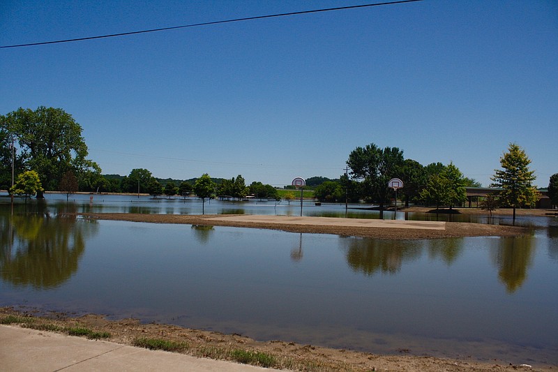
Last year, Atchison County Levee District No. 1 in Northwest Missouri embarked on a levee "setback."
The community yielded more than 1,000 acres of private and public land to the Missouri River, moving the levee farther from the river's banks and giving it room to swell during rainy years without overtopping the levees and overtaking farmers' land.
Atchison County residents said by moving their levee further back from the river banks it would give the river more room to swell during flooding, which should keep the water from overtaking farmland.
James Lowe, a spokesman at the U.S. Army Corps of Engineers in Kansas City, said the levee setback concept that was embarked on in Atchison County has been done in other areas.
"After the flood, some levees were set back because so much damage had been done to them that is wasn't feasible to build them back to where they had been," Lowe said. "The river scooped out a lot of soil, and in some places, to fill those areas back in was just not practical."
Most of the levees, though, were returned to the condition they were in prior to the flood and most stayed in their same place.
The levees along the river in Central Missouri were all repaired to the conditions and locations that they were in prior to the flood.
A bipartisan legislative effort
Last week, a bipartisan group of lawmakers in Washington, D.C., representing Missouri and other states along with Missouri River, sent a letter to the Corps, urging them to use tools and resources Congress gave them to reduce flooding along the lower Missouri River.
The Water Resources Development Act of 2020, which was signed into law in December, included language to improve and expedite the planning, development and construction of water development projects.
In their letter, the lawmakers urge the Corps to issue implementation guidance consistent with congressional intent behind the WRDA provisions and immediately use the flexibilities provided to advance critical flood control work.
Malone also said the Lower Missouri Basin Flood Risk and Resiliency Study will help identify flood-risk areas. It will likely take years to complete, but they'll be looking at structural and non-structural options for flood risk, including possibly modifying existing levees and/or the river channel.
"It's hard for some people to understand that this will take years to go through, but we're talking about a river that stretches 1,500 miles and 500 of that is in our area," Malone said.
The long stretch of the river presents its own challenges in that not all levees or conditions are the same along the river.
In the Corps' Omaha, Nebraska, district, Malone said, the majority of levees are federally funded. They are bigger and stronger and more expensive to maintain and repair.
In the Kansas City district, which includes Central Missouri, only around 10 percent of the levees are federal levees, and most of those are in the St. Joseph and Kansas City areas. Those federal levees are being improved right now as part of a multi-million dollar project because many were older levees where seepage became an issue in 2019.
The levees along the river in Central Missouri are classified as non-federal levee systems, meaning they are in the Corps program but not typically built by the Corps.
For these systems, the federal government pays 80 percent of repair costs, and levee districts pay the remaining 20 percent. The levee district may provide some or all of its percentage by in-kind work as part of an agreement with the Corps.
Most of the Central Missouri levees primarily protect farmland.
"People need to remember that what caused the 2019 flood was really bad weather at the wrong time," Malone said. "We had torrential rains on top of snow on top of frozen ground," he said. "With the volume that came down at one time and kept coming down, it would have taken levees that would have been massive in size to prevent flooding in that scenario."
'It's a complex problem'
Roger Fisher, chairman of the Heartland Port Authority Board and who also serves as Callaway County Western District commissioner, said Atchison County is using a "common sense approach" by creating a wider area for water to flow through.
"In my opinion, and everyone has one, it's not 'rocket science,'" Fischer said. "It will require a planning process including a feasibility study to get the numbers that lead us to the right decisions of where or how high our levees need to be.
"Consider it like a roof gutter, a 4-inch wide gutter will not hold as much as a 5- or 6-inch gutter," he added. "It holds true for the river. By widening the width, it would allow more 'volume of water' to flow down the river, thereby reducing the elevation of the water before it overflows."
Fisher said he is hoping to meet with officials in the next few weeks to talk about flood-control plans.
"There's no levee districts in this area that I'm aware of that have or are looking to do what the folks in Atchison County have done," he said. "Farmers probably wouldn't want to give up the property that would be needed to do what was done in Atchison County.
"We have a lot of jobs at businesses along the river that are at risk of flooding such as ABB and the Jefferson City airport. It is also vital that what we design would prevent losing our only northern access to Jefferson City - the U.S. 54/63 corridor."
Malone added: "In the end, it takes a coordinated effort to make improvements on the river. It's a complex problem, and we've never said improvements can't be made. But deciding what improvements can be made and how they will affect the next person down the river is what we have to keep in mind."