
A winter storm is expected to bring periods of freezing rain or drizzle to much of the region overnight and will begin a second round of snowfall Monday, according to the National Weather Service.
Winter Storm Warnings and Winter Weather Advisories are now in effect across most of Missouri.
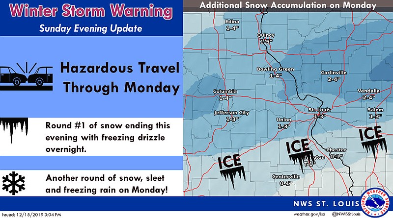
Sunday's first round of snow was forecast to transition to freezing rain or drizzle. The freezing rain or drizzle will then transition back to snow on Monday.
This winter storm could affect the commuting hours on Monday.
The NWS in St. Louis has issued the following weather statements for central sections of Missouri:
...WINTER STORM WARNING REMAINS IN EFFECT UNTIL MIDNIGHT CST MONDAY NIGHT...
* WHAT... Heavy mixed precipitation. Additional snow accumulations of 1 to 4 inches and ice accumulations of around one tenth of an inch.
* WHERE... Portions of central, east central and northeast Missouri and south central, southwest and west central Illinois.
* WHEN... Until midnight CST Monday night.
* IMPACTS... Plan on slippery road conditions. The hazardous conditions could impact the morning or evening commute.
PRECAUTIONARY/PREPAREDNESS ACTIONS... A Winter Storm Warning means significant amounts of snow, sleet and/or ice are expected. Strong winds are also possible. If travel is necessary, make sure to exercise extreme caution. Begin your travel with a full tank of gas, and carry a winter storm kit which includes a shovel, flashlight, cellphone, food and water, and blankets of extra warm clothing.
See also:
School closings and weather-related announcements for Monday, Dec. 16, 2019
MoDOT statewide traveler information map