
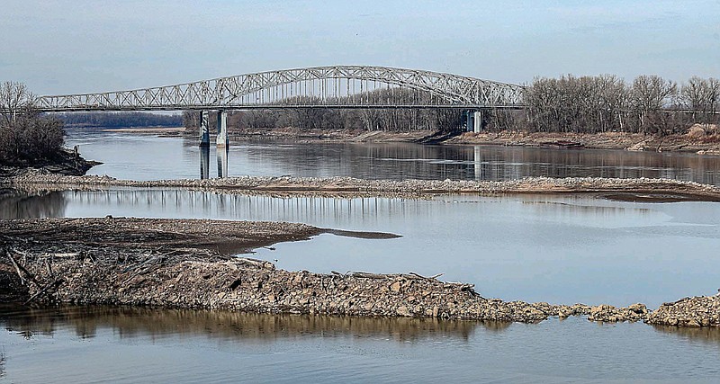
The Missouri River reached a historic low near Jefferson City last month.
The U.S. Geological Survey's Missouri River gauge recorded a water level of -2.8 feet Dec. 29.
A cold snap froze the already low river water, creating an ice jam near Boonville and sinking levels downstream to record lows.
But a lack of natural rain and snowfall throughout the middle of the country, coupled with the complicated structures and competing state interests governing the river, has resulted in declining river flow levels for the past couple of years.
The Missouri River has seen extreme weather conditions for longer, though, as cycles of severe flooding and drought plague the regions it carves through.
As a result, the Army Corps of Engineers and states in the lower Missouri River Basin -- Missouri, Kansas, Iowa and Nebraska -- are studying solutions.
The Department of Natural Resources is Missouri's lead agency responsible for environmental issues and water management, but it doesn't control the river. That falls to the Army Corps of Engineers, as the Missouri River touches seven states.
"Does the federal government manage the Missouri River exactly like the state of Missouri would like it? No," said Dru Buntin, director of the Missouri Department of Natural Resources. "But we recognize that that's always going to be a compromise with the states that are within the Missouri River basin."
The Missouri River originates in southwest Montana and flows 2,315 miles to meet the Mississippi River just north of St. Louis.
Gary Kremer, executive director of the State Historical Society of Missouri, said Jefferson City used to have a "strong connection" with the Missouri River because it was integral for trade, traffic and recreation. The lower end of Jefferson Street, now the Jefferson Landing State Historic Site, was a commercial and transportation hub for the fledgling Capital City, he said.
Kremer, who previously served as the state archivist and taught history at Lincoln University and William Woods University, recalled seeing archived photos of horses and wagons traveling across a frozen Missouri River before a bridge was built.
That all largely collapsed throughout the late 19th and 20th centuries, he said. As trains and other forms of transportation were introduced to commercial supply chains, Jefferson City turned away from the river.
"We changed," he said.
So has the river.
Buntin, who has worked on management of the Missouri River for 25 years, said the river system in place today was established in the early half of the 1900s when Congress authorized the construction of massive reservoirs in Montana, North Dakota and South Dakota.
The reservoirs are the largest in the country and can store 73 million acre-feet of water -- the equivalent to a foot of water pooling across 73 million acres.
Buntin said they were designed to respond to significant flood events and multi-year droughts. When it's a wet year, the reservoirs store water so it doesn't all travel down the river at the same time. When it's dry, they store water for times of need.
The Army Corps of Engineers releases water from the six reservoirs according to the Master Water Control Manual, which outlines thresholds for when water should be released down the river. Those thresholds are based on water levels in the reservoirs.
Buntin said the Missouri River acts like a lake in many of the reservoir states. Over the course of decades, many were developed for recreation with the addition of marinas and other facilities.
Gavins Point Dam at the border of Nebraska and South Dakota is the most southern dam on the Missouri River. Its construction in the 1950s created Lewis and Clark Lake -- a reservoir that has since become one of the most popular recreation spots in the Great Plains with more than 2 million annual visitors, according to the Corps. The lake is marketed for camping, fishing, hunting, hiking, sailing, swimming and bird watching, among other activities.
"They're not interested or they typically try to avoid those reservoir levels dramatically changing," Buntin said of the Corps management of the river upstream. "From Missouri's perspective, the problem with that is those reservoirs were designed to pretty dramatically fluctuate depending on whether we were in flood or drought."
And there's a drought.
According to the U.S. Drought Monitor, nearly half of Missouri is experiencing abnormally dry conditions and an estimated 615,824 Missourians are experiencing moderate to severe drought.
James Lowe, a spokesman with the Kansas City District of the Corps, said historically low snowfall in the plains and mountains in the basin, as well as tributary runoff, has contributed to less water in the reservoirs. Measures over the last year were about 75 percent of what they usually are, he added.
With 25 percent less water stored, he said there's less water to release.
The reservoirs have received less runoff water every year since 2019, Lowe continued.
"Although we're seeing a lot of rain and snow right now, it takes a lot to catch up when you've been behind for several years," he said.
Gavins Point is releasing about 12,000 cubic feet of water per second right now, Lowe said. Usual releases during the winter time are around 15,000 cubic feet per second.
"When you start talking about that amount of water per second, it changes the level of the water," he explained. "The general reasoning for that is that there's so much less water in the reservoirs upstream that if more water was released now, we wouldn't have enough water to keep the channel deep enough for navigation for when that navigation season starts in the spring."
In response, the Army Corps of Engineers shortened the navigation season on the Missouri River by about a week in 2022.
The navigation season, which usually runs from late March to early December, allows boats and barges to traverse only the lower 734 miles of the Missouri River from Sioux City, Iowa, to St. Louis. More than 140 docks and terminals operate along the river.
"When we think about the Missouri River, we're thinking about it from a water supply perspective, a recreational perspective, a water quality perspective and a transportation perspective as well," Buntin said, adding the agency is in continuous contact with the Corps about water releases out of upstream reservoirs.
The Corps is now on a winter water release schedule, which Buntin said is a lesser flow not designed to support navigation. The amount of water flowing down the river should still support water supplies and power cooling.
Missouri American Water Company draws Jefferson City's water supply from the Missouri River and, downstream, Ameren's Callaway County nuclear power plant draws cooling water from the river.
With a record low flow last month, Buntin said it raises concerns about the ability of power plants and drinking water suppliers to intake water.
"When we're in drought and the Corps and the Western states are in drought where the reservoirs are, it just combines to really create a problematic situation for us," he said. "And we're much more vulnerable when the river is low to these freeze-up conditions because when you've got less water quantity in the river it's going to be more susceptible to freeze."
"When we think about the Missouri River, whether it's in Jeff City or anywhere else, what we're trying to achieve is to balance the multiple uses of the river," Buntin said.
Missouri filed a lawsuit against the federal Bureau of Reclamation to prevent the diversion of 13 million gallons of water per day from the Missouri River to parts of central North Dakota, arguing residents in Missouri needed the water. The federal judge overseeing the case ruled against Missouri in 2021.
"Just like the Colorado River, we're concerned about consumptive use upstream of us -- how much water is being depleted, how much water is being diverted into other river basins that would have otherwise flowed past Jeff City," Buntin said. "It is an ongoing concern and something that we battle. Missouri has always opposed any diversions of water out of the Missouri River basin, and that goes back decades."
When the Corps last reviewed its Master Water Control Manual in the early 2000s, Buntin said DNR advocated for water to be released at levels that would meet the needs of Missourians.
Modifying that Master Water Control Manual is no short order, Buntin said. Last time, the process involved about 15 years of negotiations, congressional actions and lawsuits -- some of which Missouri initiated. Plus, there's no guarantee Missouri would get better results, he said.
The area of opportunity, Buntin said, rests with river infrastructure in the state and working with the other states in the lower basin -- Kansas, Iowa and Nebraska.
Below the reservoirs, local levee districts are the primary method of water flow control on the Missouri River, Buntin said.
The system in place for the lower Missouri River -- or lack thereof -- differs from that of the lower Mississippi River. After the flood of 1927, Congress authorized the construction of a levee and floodway system on the Mississippi designed to effectively pass flood waters while minimizing damage.
"We don't have anything like that on the Missouri River," Buntin said. "Congress originally authorized the Pick-Sloan Plan that had envisioned a comparable system on the Missouri River but that was never completed."
A Corps study looking at the lower Missouri River basin seeks to do some of that work, Buntin said.
Missouri, Kansas, Iowa and Nebraska are partnered with the Army Corps of Engineers on a lower Missouri River basin study looking at flood mitigation and resiliency.
The collaboration was spurred by the 2019 flood, which inundated the Jefferson City Memorial Airport and businesses on the north side of the river, Buntin said.
Colleen Roberts, who coordinates lower Missouri River studies for the Corps, said involving all four states is a huge deal because the study will look at a system plan for the lower 735 miles of the river.
"That's like our huge study, once in a generation opportunity," she said. "It's really exciting to look at to address the repetitive flooding that's kind of occurred over the last 30 years."
With floods in 2010, 2011, 2018 and 2019, Roberts said four of the six most severe flood events have happened in the past decade.
She said the Corps uses feedback from states to fully understand the regions around the river and what life is like for residents there.
"We have a pretty good idea on where our vulnerabilities are in the system just because we have a lot of folks, we get out there, we're on the ground during the flood events, and we're talking with those people," Roberts said. "But we don't see those real life impacts or what happens even after those flood events so it's really beneficial to get their feedback."
The Corps has three smaller "spinoff" studies looking at specific areas along the Missouri River. In Missouri, those areas are Jefferson City, the confluence of the Grand River in Brunswick, Missouri, and Holt County in the northwest corner of the state.
Roberts said the problems at each location are the same as far as flood damage and the need to improve resiliency, but each will require unique solutions. The three-year studies will likely produce some kind of construction project, from levee raises or setbacks to non-structural measures.
Buntin said he expects the projects to provide landowners better protection from flooding, increase recreational opportunities, and support wildlife habitats and water quality benefits.
The study hasn't progressed much since Nov. 28, when Buntin signed the 50/50 cost-share agreement with the Army Corps of Engineers.
Roberts said the Corps is waiting for the state's portion of the project funding, which should arrive before the end of the month. Once that's in, the Corps will review available data and start brainstorming the scope of the project. It plans to reach out to partners and stakeholders after that, she said.
The Army Corps of Engineers would typically wait for the completion of the larger system study before progressing on the small spin-off studies, Roberts said, but the agency has specific authority to run them concurrently to produce results more quickly.
Jefferson City was studied a couple decades ago, and the Corps authorized plans for a controversial 16-foot-high L142 levee near the airport. It was never built as funding was diverted elsewhere.
Dane Morris, the Corps's program manager for Missouri River navigation restoration, said flooding degrades river structures, such as dikes and revetments that make the river navigable.
The Corps's Kansas City District oversees the bottom 498 miles of the river.
In 2019, flooding damaged more than 5,000 Missouri River structures in the Kansas City District, Morris said. Since 2019, the district has received approximately $348 million to repair those navigation structures, a large chunk of which came from the Bipartisan Infrastructure Law passed in 2021.
Morris said it's a significant project that he expects to take through 2025. About 1.5 million tons of rock have been added to dikes and revetments so far, he said, and there's another 3.7 million tons to go.
But, Morris said, the Corps is "looking down the barrel of another low-water year" because of drought in the upper basin.
"We're expecting in 2023 to have what we refer to as minimum flow support coming out of those reservoirs," he said. "So that will impact the ability of the navigation industry to navigate the river."
With minimum flow support, Morris said, the navigation channel would likely be around 200 feet wide and 8 feet deep. It's normally 300 feet wide and 9 feet deep. The reduction will impact how many barges can be pushed and how much weight they can carry, he said, but likely not until precipitation drops off at the end of the summer.
If the Missouri River is low because the Corps cuts down on water releases, Buntin said, it can have dramatic effects on the Mississippi.
"If we start seeing reductions in the Missouri River having impacts in navigation on the Mississippi River, it has a huge economic impact," he said. "And it also has the potential to have the same effect and concerns about water intakes on the Mississippi River."
Because the flow of the river is so heavily determined by releases from reservoirs, Buntin said the real measures of whether river levels are sustainable are reservoir levels and an increase in navigation season shortenings -- like what the Corps did last year.
"These conditions can change, and I've seen them change very dramatically in short periods of time," Buntin said. "But right now, the reservoirs are low. The mountain snowpack and the plain snowpack is fairly low. So right now, my concern would be that we're going to see drought conditions persist and that we're going to be more vulnerable to drought conditions than we are flood conditions."
Sean Zeiger, a professor of forest hydrology and watershed management at Lincoln University, said dramatic fluctuations in Missouri River depth readings in Jefferson City signal the extreme hydroclimate of the lower basin.
"The minimum here was 22,600 cubic feet per second, recorded in 2022," he said looking at gauge data. "The maximum, recorded in 2020, was 143,000 cubic feet per second."
"Not only are we seeing record-setting low depths, we're also seeing record-setting max depths at this gauge, and it's all very recent," he continued. "We're seeing a lot of extremes."
Roberts, from the Corps, said the extremes seen on the river -- from severe floods to severe drought conditions -- indicate why it's important to look at the river systematically.
Zeiger is part of a multi-university project studying how droughts, floods and water quality issues impact underserved communities along the Mississippi River. He said the low water levels along the Missouri River have been part of recent discussions.
He's also drafting a proposal to get funding for a climate resiliency center at Lincoln University, which would allow different faculty to study and address weather issues, from floods to extreme cold snaps and heat waves, in underserved communities.
Buntin, whose department manages the state parks system, said Missouri has never taken full advantage of the recreational benefits the Missouri River offers, but he'd like to change that. Development of the Katy Trail near the river is progress, he said, but "we've only begun to scratch the surface."
The recent low river levels offer an opportunity to study the banks for a port project in the works, Callaway County Commissioner Roger Fischer said.
Fischer is the vice president of the Heartland Port Authority, which is developing a Missouri River port near Jefferson City. Fischer said the authority is looking at sites to determine where a port would be most efficient for river navigation, avoiding physical obstacles and accessing highways.
He said right now, it's focused on a single site in the 63 bottoms area.
"Just a few years ago, we had record flooding, and now we're seeing record lows," he said. "But it does provide us the opportunity to study the bank configuration to make sure we get the dock to face in the right location."
With ongoing studies and projects, Fischer said, he's confident the Army Corps of Engineers will manage the river to mitigate any risks potentially associated with navigation or building a port.
"I feel very confident that they'll be able to continue to provide us with a navigation season just as they have in the past," he said.