
Jefferson City officials think everyone heeded the city's evacuation order and left North Jefferson City before the floodwaters came.
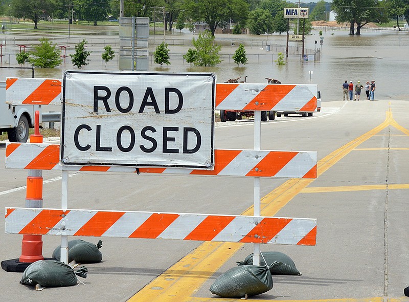
Flood waters came late Friday morning, when the Missouri River breached the Capital View levee and created a 30-40 foot gap, allowing the water to rush in.
"The water actually had been coming over since (Thursday) evening, in multiple locations and in small amounts," Britt Smith, Jefferson City operations director, told the News Tribune. "We deployed folks and tried to defeat the breach, but unfortunately, we weren't able to stop it."
As the water continues to pour through the breach, Smith said, the gap likely will grow wider.
"The more that it erodes, the harder it will be to repair," he said.
At a special Jefferson City Council meeting, Smith compared the land behind the levee to an empty bathtub set afloat in an ocean.
"Eventually, water begins to fill the bathtub and, depending on how much water comes over the top, depends on how fast it fills," he said. "So, as a result, that bathtub, if you will, behind the levee is filling."
That levee generally protects North Jefferson City, in southern Callaway County, from floods that are below 30 feet, or 7 feet above flood stage - which is 23 feet, as measured by a gauge on the eastbound bridge over the river.
After the breach, water began filling the Callaway County flood plain and, late Friday afternoon, had reached the Memorial Airport taxiways.
Even before Friday's levee breach, the threat of flooding had caused the Salute to Veterans Corp. to cancel this year's Memorial Weekend Airshow, that had been moved to Jefferson City this year from its long-time home at Columbia Regional Airport.
The National Weather Service said the river crested at 31.7 feet - 8.7 feet above flood stage - about 2 p.m. Friday, making it the ninth biggest flood at Jefferson City, according to NWS statistics.
The river was predicted to drop below flood stage by 2 p.m. June 1.
In a note on its website for Jefferson City river levels, the Weather Service noted: "River forecasts for this location take into account past precipitation, and the precipitation amounts expected approximately 24 hours into the future from the forecast issuance time."
So more rainfall or storms than were expected Friday in the Missouri River Basin north and west of Jefferson City could increase water levels and delay the end of the flooding.
Transportation problems
Some motorists told the News Tribune they were concerned U.S. 63 - coming into the U.S. 54 interchange in North Jefferson City - would be forced to close.
But a Missouri Department of Transportation official said the river level was at least 5 feet lower than needed to cover the road.
However, the flooding did contribute to traffic delays Friday evening, as the normal Memorial Day weekend traffic congestion included people who slowed to look at the flooding.
"We had reports of people stopping on the shoulder to take photos," Sgt. Scott White, the Missouri Highway Patrol's Troop F information officer, told the News Tribune
The flooding also extended the use of buses instead of trains for Amtrak's Missouri River Runner.
Train service had been expected to resume Friday, but the state Transportation Department announced Friday they now expected the Amtrak service to resume Sunday.
A number of area state roads continued to be closed Friday, including:
Missouri 179, near the Route Z intersection in Cole County and at Sandy Hook in Moniteau County.
Moniteau County Sheriff Tony Wheatley told the News Tribune: "We also have several creek crossings in that area that are impassable."
He said the Missouri River flooded into Lupus on Thursday, with 3 feet of water and still rising.
"The citizens have moved their vehicles to higher ground and are used to the flooding in that area," Wheatley said.
Other area roads that have been closed include:
Missouri 94 at several locations in Callaway County, including between Steedman and Portland.
Route C in Callaway County, at Mokane.
Missouri 100 in Osage County, east of Bonnots Mill, between St. Aubert and Chamois.
Route W in Cole County, from south of Wardsville to Osage Band.
The Cole County Public Works Department said Friday that county roads closed by flooding included: North Branch, Murphy's Ford, Meadows Ford, Engineers and East Cole Junction roads, and Railroad and Water streets.
Missouri River flooding downstream
The river crested at Chamois on Friday afternoon at 27.3 feet, or 10.3 feet above flood stage - but more than a foot below the crest that had been predicted. Forecasters said it likely would fall below flood stage June 5.
At Gasconade, the Missouri was expected to crest Friday evening at 34.8 feet, or 12.8 feet above flood stage. Forecasters predicted it would fall to 24 feet by June 5.
At Hermann, the Missouri was expected to crest before 5 p.m. Saturday at 32.1 feet, or 11.1 feet above flood stage. Forecasters predicted the Missouri River at Hermann would be below flood stage by June 5.
EARLIER COVERAGE:
The Missouri River on Friday breached the Capital View levee that protects North Jefferson City from many floods.
City officials said the river created a 30- to 40-foot gap in the levee, allowing the water to rush in.
The National Weather Service said the river crested at 31.7 feet - 8.7 feet above flood stage - about 2 p.m. Friday.
That would make it the ninth-biggest flood at Jefferson City, according to NWS statistics.
And, in response to various motorists' concerns that U.S. 63, coming into the U.S. 54 interchange in North Jefferson City would be forced to close, a Missouri Department of Transportation official told the News Tribune the river level was at least 5 feet lower than needed to cover the road.
However, the flooding did contribute to traffic delays Friday evening, as the normal Memorial Day weekend traffic congestion included people who slowed to look at the flooding.
"We had reports of people stopping on the shoulder to take photos," Sgt. Scott White, the Missouri Highway Patrol's Troop F information officer, told the News Tribune
Weather resources:
Mid-Missouri weather advisories via Twitter
Ameren's Truman and Bagnall Dam daily report
Missouri state highway road closings