
While water levels on the Missouri and Osage rivers continue to decrease, the Osage County Sheriff said Monday there is more damage on the Osage River and a levee breach along the Callaway County side of the Missouri River, west of Chamois.
Osage County Sheriff Michael Bonham said he noticed a levee breach at about mile marker 119.2 on the Missouri River while on a recent boat patrol.
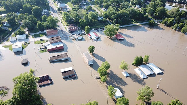
Bonham said farm fields have been affected, but "it's a pretty good chunk of the levee" that's been breached.
He added damage to docks along the Osage River in the area of Osage Delta Drive, east of Osage City, had gotten worse, and it was apparent that water had gotten inside more homes in the area.
The city of Chamois posted to its Facebook page over the weekend that tetanus shots are available at the Osage County Health Department, and the shots are for anyone living in Osage County.
The Osage River crested at Mari-Osa Campground at 30.2 feet sometime between 4 a.m and 4 p.m. Thursday, and has been falling since, according to the National Weather Service.
The National Weather Service observed a level of 28.5 feet on the Osage at the campground at 6 a.m. Monday. The forecast was for the river to drop to just above 26 feet by 4 p.m. Friday, but then increase to just below 27 feet by 4 p.m. Saturday.
The river would still be in major flood stage. Major flood stage at the campground is at a level of 25 feet.
Farther upstream, the Missouri Highway Patrol announced Monday the Osage River from Bagnell Dam to the Route B bridge in St. Thomas is now open for recreational boating traffic.
"While this section of the river has been opened, boaters should avoid creating wakes in areas still experiencing high water conditions. Boaters should also be alert for floating debris," according to a news release from the patrol.
The Osage River from the Route B bridge downstream to the Missouri River remains closed to recreational boating traffic, until further notice.
"Although the river level continues to drop, there are still flooded structures downstream from the Route B bridge," according to the patrol.
The patrol closed the Osage from Bagnell Dam to the Missouri River on June 4.
The National Weather Service observed a river level of 16.39 feet on the Osage near St. Thomas at 3:45 p.m. Monday. Minor flood stage there is at a level of 23 feet.
The forecast was for the Osage near St. Thomas to reach minor flood stage sometime Friday, and reach 25.1 feet by 4 p.m. Saturday.
The Missouri River near Jefferson City was observed at 31.92 feet at 3:45 p.m. Monday. The NWS forecast was for the river to be below 30 feet and in moderate flood stage by 4 p.m. Thursday and to be below minor flood stage of 23 feet sometime between the afternoon of Friday, June 21, and Saturday, June 22.
Additional weather resources: