
Gov. Eric Greitens declared a state of emergency in response to flooding Saturday across Missouri, as more rain and the likelihood of additional flooding remained in the forecast through this evening.
The State Emergency Management Agency, the Missouri Highway Patrol, Missouri National Guard and the state's Task Force 1 Rescue Unit deployed resources to assist during the crisis.
The flooding killed at least one person in the state and prompted nearly 100 evacuations and 33 rescues after a storm that moved from the southwest to the east dumped 3-9 inches of rain on saturated grounds and waterways.
The Patrol says a woman died after being swept away by flood waters Saturday near Clever in southwest Missouri. Troopers responding to a call for help were able to rescue a man traveling with the woman.
Meanwhile, heavy rains in Mid-Missouri Saturday threatened residents and interrupted many activities, from school sports to fundraisers.
A few braved the weather, like those supporting the Marine Corps League barbecue at Schulte's Fresh Foods.
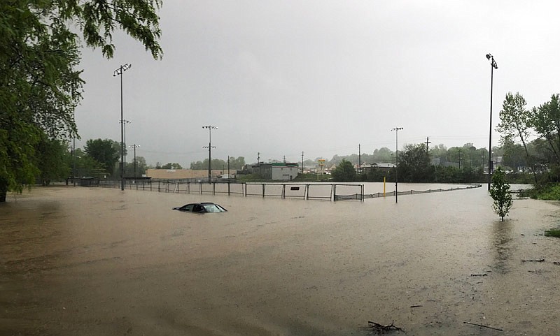
By mid-day, Wears Creek in Jefferson City was out of its banks, covering Vivion Field and Washington Park, where a stuck vehicle eventually was engulfed by the waters after the driver evacuated.
No major power outages had occurred by Saturday evening in the city. But scattered outages of less than 100 users at a given time were reported during various waves of weather and lightning, officials said.
The Osage Fire Protection District responded shortly after 6 p.m. to a home in the 100 block of Highland Waye in Cole County. Firefighters discovered smoke in the structure from a lightning strike.
The Callaway County Sheriff's Department responded Saturday to a call about endangered residents.
"The Middle River is rising rapidly," Sheriff Clay Chism said. "Three residences on County Road 411 were completely surrounded by water."
He said the occupants of the houses were brought to safety with the aid of deputies and local firefighters.
More than 150 state roads across Missouri were closed due to rising water levels with more expected through the rest of the weekend.
Sections of several Cole County roads also were closed Saturday by floodwaters, including Scrivner, Campbell, Payne, North Branch, Loesch, Banner, Waterford, Murphy's Ford, Meadows Ford, East Lohman Rockhouse Spur, Vaughn Ford and Scott Station roads.
The Missouri Department of Transportation (MoDOT) recommends caution and encourages drivers to check its online Traveler Information Map at modot.org for flash flooding updates.
Not all flooded roads will have closure signs, MoDOT said.
Drivers are reminded never to drive through water over the road, find an alternate route.
When the water recedes, MoDOT will inspect the pavement and bridges for safety, before reopening the roadways for public use.
MoDOT recommends the following precautions in areas affected by flooding:
Low water crossings are among the most dangerous spots. Never attempt to cross one that is flooded.
Never drive past a barricade closing flooded roads. They are there to protect you.
Never expect barriers to block off flooded low-water crossings, bridges or roads because flash flood waters often rise so quickly authorities do not have time to respond.
If your vehicle becomes stuck in rising water, get out quickly and move to higher ground because rapidly rising water may engulf the vehicle and sweep it away.
In the rain, if your wipers are in use, your headlights should be on, too. It's the law.
National Weather Service (NWS) hydrographic information at water.weather.gov provided the following local river flooding predictions, as of Saturday night:
The Moreau River near Jefferson City has exceeded flood stage, at 17 feet, and is expected to peak at 28.4 feet this evening.
The Missouri River near Boonville is expected to reach flood stage, at 21 feet, by noon Monday, according to the National Weather Service predictions. Then, it should peak at about 23.8 feet by noon Tuesday.
The Missouri River at Jefferson City should reach flood stage, at 23 feet, about noon Tuesday and peak at 23.3 feet by Wednesday.
The Missouri River near Chamois is expected to reach flood stage, at 17 feet, about 11 a.m. today and should peak at 20.9 feet about 11 a.m. Wednesday.
The Osage River near St. Thomas, where flood stage is 23 feet, was recorded rising at 18.2 feet Saturday night.
The Maries River at Westphalia has passed the flood stage of 10 feet and was expected to peak at 17.5 feet by this evening.
At 9 p.m. Saturday, Ameren Missouri reported the discharge rate at Bagnell Dam was 34,570 cubic feet per second.
With more heavy rain expected, the NWS continued a flash flood watch for most of central and southern Missouri through this evening.
The Associated Press provided some information for this story.
Additional information:
Current weather watches, warnings and advisories for Missouri
Missouri rivers and lakes stages, forecasts
Bagnell Dam and Truman Reservoir stages, releases